↧
“Mogadiscio – Moschea Scek-Sufi”


↧
“Mogadiscio – Campo Amnara”
 Click on photo to enlarge
Campo Amhara, in what was latter called Abdul Caziz District (I think). Centre of town to the right.
Leave your comment on where this is
Filed under: 1900 - 1918, Govt buildings


↧
↧
“Mogadishu – Panorama”
 Click on photo to enlarge
Location unknown, but appears to be looking inland
Leave your comment
Filed under: 1900 - 1918, Street scenes


↧
“Mogadiscio – Viale Cerrina”
 Click on photo to enlarge
Viale Cerrina, later named Via Vittorio Emmanuel, then Via Somalia (I think). Leave your comment below
Fakhr al-Din mosque visible in the centre
Filed under: 1900 - 1918, Govt buildings, Street scenes


↧
“Mogadiscio”
 Click on photo to enlarge
Photo copied from Vintage Somalia – a website worth visiting, with a large and eclectic collection of photos
When was this photo taken? Leave your comment below
Boondhere district is visible as a new settlement in the distant centre and right
Filed under: 1900 - 1960 Italian Period, Aerial photographs


↧
↧
“Mercato di Mogadiscio”
 Click on photo to enlarge
“Market of Mogadishu” circa 1901 (from an Italian magazine) Possibly the Garessa on the left and Shangani in the middle distance. What do you think? Leave your comment.
Filed under: 1900 - 1918, Markets


↧
“Autorita indigene di Mogadiscio”
 Click on photo to enlarge
“Indigenous authorities of Mogadishu”, circa 1901 (from an Italian magazine). Who are the people shown here and where was the photo taken? Leave your comment below.
Filed under: 1900 - 1918, People


↧
“Mogadiscio – interno della moschea Giama”
 Click on photo to enlarge
“Mogadishu – Interior of the Giama mosque”, circa 1901 (from an Italian magazine). Any comments?
Filed under: 1900 - 1918, Religion


↧
“La via principale di Mogadiscio”
 Click on photo to enlarge
“The main street of Mogadishu”, circa 190 (from an Italian magazine). Where is this scene? Leave your comment below
Filed under: 1900 - 1918, Street scenes


↧
↧
“Mogadiscio – Mercato Amaruin”


↧
Map of Mogadishu – City Centre in the1970s?
 From page 5 of “Mogadishu: Pearl of the Indian Ocean” (pdf copy here)
Undated, could be in the 1970s.
Filed under: 1969-1991 Barre period, Maps 

↧
Somali government and other publications from the 1970s
Available via Tobias Hagmann’s website:
- Mohamed Sheikh Ali Giumale (undated), Mogadishu: Pearl of the Indian Ocean. Mogadishu: Local Government.
- Somali Democratic Republic (1971), Beautiful Somalia. Mogadishu: Ministry of Information and National Guidance.
- Somali Democratic Republic (1977), New Era Quarterly Magazine, Issue No 4, Oct./Dec. 1977. Mogadishu: Ministry of Information and National Guidance.
- Somali Democratic Republic (1979), Selected Speeches of the SRSP Secretary General and the Somali Democratic Republic President, Jaalle Mohamed Siad Barre. Mogadishu: Ministry of Information and National Guidance.
Plus
- Puzo, W. D. (1972), Mogadishu, Somalia: Geographic Aspects of its Evolution, Population, Functions, and Morphology. PhD thesis, University of California, Los Angeles.
Filed under: 1969-1991 Barre period, Text


↧
Somali coast, circa 1688


Title: Coast of Zanguebar and Aien
Creator: Morden, Robert
Place of Publication: England
Date: 1688
Published in Modern’s Atlas Terestris.
More information: http://imagesearchnew.library.illinois.edu/cdm/singleitem/collection/africanmaps/id/1066/rec/9
Described as “Rare early English map of the East African Coastline, perhaps the earliest obtainable English map of the region” The above version seems to have been colored after removal from the atlas
Filed under: 1800 < before, Maps, X: Other locations


↧
↧
Mogadishu, circa 1935


↧
Djibouti, 1929


↧
Pre-colonial port, remains circa1882
 From “Voyage Chez Les Benadirs, Les Comalis et les Bayouns, par M.G. Revoil en 1882 et 1883″
Published in Le Tour du Monde. Noveau Journal des Voyages. XLIX, 1255 Liv, page 49
Text on page 50 refers to this view [courtesy Google Translate):
Along the narrow streets of Harmarhouine amid the huts and miserable huts along them, we arrive at the mosque of Hussein Arbou . This edifice , without much importance , dominates a small cove almost square, closed by the nature in which the sea, which breaks with fury on the rocks, pours a veritable cataract of foaming waves , while iridescent by the rays of the sun . Some sections of blackened walls surrounding the mosque, based as it on an entablature of the cliff and peak ground in many places by the hand of man . A little further , the old men say , was a tower of similar construction to the Abdul Aziz tower , and high enough so that we could see it from Meurka . This tower , no marks on the rock, however, it differs in the reef a sharpened screw which, through arched doorway , built strong regularly and a Moorish character quite remarkable staircase gives access to a cave formed by the upper entablature . No clue, no registration revealed the date of the ruins. The other side of the creek, a cut in the rock street is facing the door , and can still be seen , right and left , a few walls identical to those adjoining the mosque. This cove she was a small port of refuge intended to park the boat against the violence of the monsoon ? or was it used basin repair a flotilla of Moguedouchou ? It is difficult to say today , but there has certain is that the cave and its surroundings bear traces of human labor . I have natural claims to have found several times small pieces of gold , as for me, I have hardly discovered around these lands broken fragments of pottery and glass beads without much interest. South of the basin , which extends the space between the mosque of Hussein Arbou and that of Aoues al- Garni forms a small cove covered at high tide. The low tide leaves has discovered a kind of platform rocks mishap by algae , and there is generally less research by women for bathing or laundry. Holes that serve tubs or swimming pools seem to have been in all probability foundations of a dead city , once sitting on rocks. But since water and sand walks slowly to the conquest of the rocks, and it was difficult for me to really reconaitre if these ruins were the same age as the Arbor -Hussein stairs. Who can say how many thousands of years have passed since the first inhabitants of these beaches?
If you think you can improve this admittedly rough translation contact me and I will send the original French text
Here below is a later view of the area, shown in a map titled "Oceano Indiano - Somalia Italiana Ancoraggio di Mogadiscio. Dai rilievi Originali della Regia Nave - Staffetta,, 1911 e da Quelli Successivi Fino al 1934" [Indian Ocean - Italian Somalia Anchorage of Mogadishu. Original Surveys by the Royal Ship "Relay" 1911 Subsequent to Those Until 1934 "] The “small cove almost square” can be seen in the red circle. Around 1985 I remember seeing the eroded remains of a spiral staircase that had been cut down into the rock, giving access to the water line within the cove

And here is a Google Earth view of the same location, showing the mosque on the top right of the cove

Filed under: 1800 - 1900


↧
Fakhr al-Din mosque, circa 1882
 From “Voyage Chez Les Benadirs, Les Comalis et les Bayouns, par M.G. Revoil en 1882 et 1883″
Published in Le Tour du Monde. Noveau Journal des Voyages. XLIX, 1255 Liv, page 51
More engravings from the same source:


For more information about the marbles, see
Lambourn, E.(1999) ‘The decoration of the Fakhr al-Dīn mosque in Mogadishu and other pieces of Gujarati marble carving on the East African coast‘, Azania: Archaeological Research in Africa, 34: 1, 61 — 86 To link to this Article: DOI: 10.1080/00672709909511472 URL: http://dx.doi.org/10.1080/00672709909511472. The first paragraph, showb below, suggests that the marbles shown above may not longer be in place:
 The following photos are included in the above paper
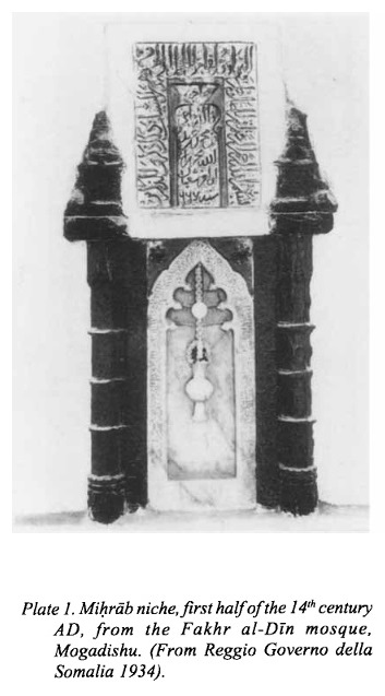

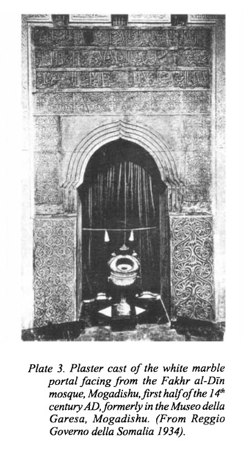 Is this four layered inscription above the arch the same as marble incriptions photographed by Revoil and shown above (but in the proper vertical order)?
Filed under: 1800 - 1900, Themes


↧
↧
Cabdul Aziz mosque, circa 1880
 From “Voyage Chez Les Benadirs, Les Comalis et les Bayouns, par M.G. Revoil en 1882 et 1883″
Published in Le Tour du Monde. Noveau Journal des Voyages. XLIX, 1254 Liv, page 46
Revoil and his colleague are in this scene, wearing turbans, located to the left of the camera on the tripod
Location as shown by Google Maps. Given the location of mosque relative to minara, it seems that the above drawing was based on a location to the south east of the minara
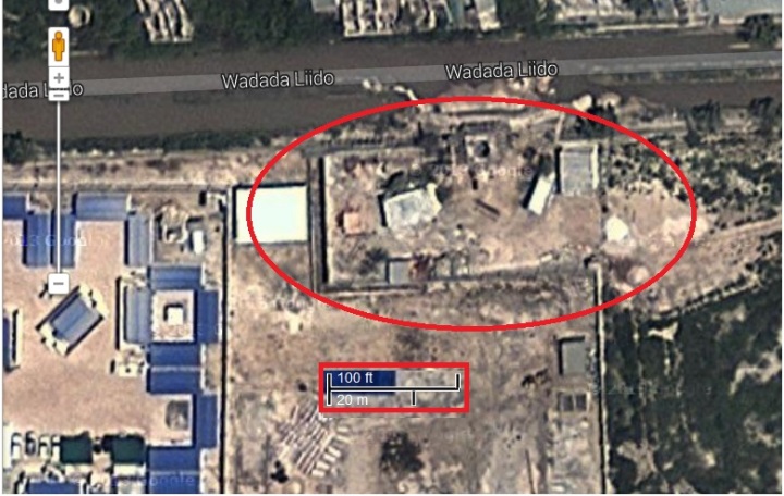
Alas it is no more, after being damaged by fighting between Al Shabab and OAU forces a few years ago, and then in 2013 demolished by order of the current government, with a promise of being “rebuilt” by Turkey
Here are some photos of inscriptions inside of the adjacent mosque (also damaged during the fighting), taken by Mary Harper before its demolition
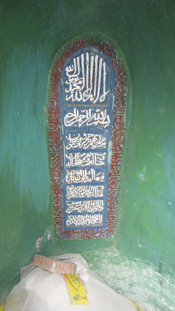
Located at the back of the mihrab?
 Old inscription or simply recent text written in chalk?
Location unknown…any ideas?
Filed under: 1800 - 1900, Mosques


↧
Jama mosque, circa 1880
 From “Voyage Chez Les Benadirs, Les Comalis et les Bayouns, par M.G. Revoil en 1882 et 1883″
Published in Le Tour du Monde. Noveau Journal des Voyages. XLIX, 1255 Liv, page 61
Location in Xamar Weyne, courtesy of Google Maps. Minara is visible within the red circle

Filed under: 1800 - 1900, Mosques


↧
Gendershe ruins
 From the Wikipedia entry on Gondershe , with a photo dated as 2008.
But I query the date. The ruins look much more visible here than they did when I visited in site the 1980′s. At that time they were much more overgrown with scrub. And the 2011 Google image below also shows them to be very overgrown, and possibly less intact than the photo above.
The location, as visible via Google Maps

Filed under: 1980s, X: Other locations


↧